
Developed by Global Fishing Watch, a non-profit organization supported by Google Interactive map Which allows human activity at sea to be followed with an unprecedented level of accuracy thanks to the use of satellite images and artificial intelligence. In this way, the so-called ship viewer reveals everything from suspicious fishing operations to the explosion in offshore energy development.
The maps published by Nature magazine on Wednesday reveal this Three-quarters of the world's industrial fishing vessels are not publicly tracked. In contrast, up to 30 percent of transport and energy vessels also escape monitoring.
Researchers say these blind spots represent an obstacle to global ocean conservation efforts, as a more accurate picture of how sea resources are exploited is needed.
Almost all nations on Earth have agreed to the common goal of protecting 30 percent of the Earth's land and water by 2030, as proposed by the Kunming-Montreal Global Biodiversity Framework adopted last year.
“You can't have discussions about where fishing activity is occurring and where oil rigs are located unless you have this map,” says David Kroodsma, one of the authors of the Nature article and director of research and innovation at Global Fishing Watch. .
Until now, Global Fishing Watch and other organizations have relied mainly on the marine Automatic Identification System (AIS) to find out what is happening at sea. This system tracks ships carrying a box that sends out radio signals, and the data has been used in the past to document poaching and forced labor on ships.
However, This system has important limitations.. Requirements to carry AIS vary by country and ship type, while it is very easy for anyone to turn off the box when they want to avoid detection or navigate in places where the signal strength is erratic.
To fill in the blanks, Kroodsma and colleagues The researchers analyzed 2,000 terabytes of images from the European Space Agency's Sentinel-1 satellite constellation. Instead of taking traditional optical images, which is the equivalent of taking pictures with a camera, Sentinel-1 uses advanced radar instruments to monitor the Earth's surface, detecting marine activity that AIS misses.
Researchers developed Three deep learning models to analyze collected data Classifying each discovered ship, estimating its size and identifying different types of infrastructure.
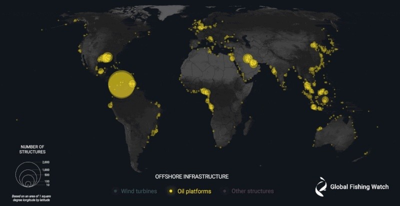
They monitor about 15% of the world's oceans, where 75% of industrial activity takes place.With attention to ship movements and the development of fixed marine structures, such as oil platforms and wind turbines, between 2017 and 2021.
While fishing activity slowed at the start of the COVID-19 pandemic in 2020, they found heavy vessel traffic in areas that “previously showed little or no vessel activity” in public tracking systems, particularly in South and Southeast Asia, and in coastal areas. North and West Africa.
The data also reflects a boom in offshore energy development. Wind turbines, which outnumbered oil structures at the end of 2020, accounted for 48 percent of all ocean infrastructure the following year, while oil structures accounted for 38 percent.
Almost all offshore wind development has taken place off the coasts of northern Europe and China. In the northeastern United States, opponents of clean energy have tried to incorrectly link whale deaths to the development of offshore wind, even though evidence suggests ship collisions are the problem.
Oil hulls have many more ships circling around them than wind turbines, and the number of oil hulls increased by 16% in the five years studied. Meanwhile, offshore oil development was associated with a five-fold increase in ship traffic globally in 2021 by comparison. With wind turbines.
:quality(85)/cloudfront-us-east-1.images.arcpublishing.com/infobae/B5A7LM6HVVCQ7GMO42K6Y3QUEU.jpg "The Venezuelan regime prevented a delegation from the Spanish Popular Party from entering to observe the elections.")
:quality(85)/cloudfront-us-east-1.images.arcpublishing.com/infobae/TTMX4RVB62WDAXL4WZ2WRAVRSE.jpg "Senator Bob Menendez convicted of accepting bribes in gold bars and luxury cars")
:quality(85)/cloudfront-us-east-1.images.arcpublishing.com/infobae/OVPEHD3JLVENTCHIRGQMS6DMJY.jpg "An impressive discovery in New Zealand: They found one of the rarest whales in the world")
