If national sovereignty has always been a complex issue, last week something else was added: Paraguay’s government decided to officially add US military rivalry to what they also call “Hidrovía”.
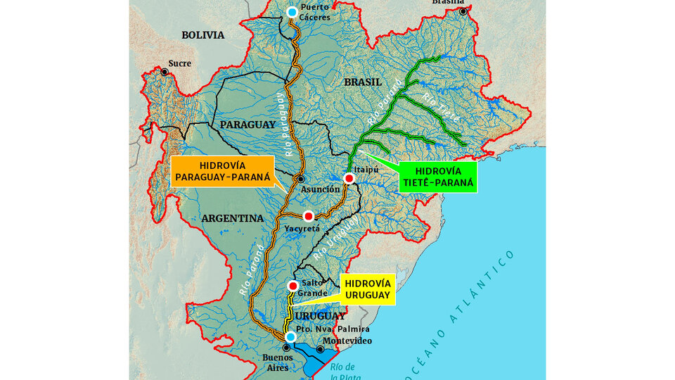
Thus, the development of a master plan for the navigation of the Paraguay River (which empties into the Paraná into Isla del Cerreto in the Chaco, which all studies and analyzes call a “meeting point”) will be carried out with “technical support from the body of military engineers of the United States.”
This has been coming for a long time, although so far everything about the Paraná-Paraguay water continuity depends more on Argentine hesitations as to the control and management of the river and the initiation of the Magdalena Canal. What can lead to another insidious group of tenders like 30 years old.
That would explain, by the way, the recent presence of the powerful Dutch dredging company Boskalis, (already mentioned in this column a couple of weeks ago) which will lobby to control the business and under the pretext of coordinating dredging, ports and agriculture. Export companies.
All of this continues to delay the implementation and operation of the Magdalena Canal, an already necessary work that will be of exceptional importance to the province governed by Axel Kiselov, and whose invitation to bid is resisted by the agricultural export sector.
Thus, the North American presence in the 542 kilometers of the river under Paraguayan sovereignty will now come into play. Perhaps this is why it is known at this time in Asuncion that Paraguay and the United States are adding military engineers to build the Paraguayan section of the so-called “waterway”.
The Paraguay River was born in the Brazilian region of Mato Grosso do Sul, from where it flows through the so-called Great Pantanal, then forms part of the border between Brazil and Bolivia, and finally enters Paraguay from north to south and below. The exclusive sovereignty of the Government of Asuncion. Where it also passes before the border between Argentina and Paraguay is drawn where it receives one of its great tributaries on the right bank: the Pilcomayo River which forms the northern border of the Argentine Republic.
From there it floods the coasts of the province of Formosa until it meets the neighboring river Bermejo which comes from the north of Salta and which extends for 1,000 km and with impressive force receives Paraguay and flows on the right bank of the Paraná in the Chaco Isla del Cerrito, in front of the Corrientes Paso de la Patria.
This is the so-called “meeting” point, from which and for a distance of 1238 kilometers the Paraná River is under exclusive Argentine sovereignty, although irregular for about 30 years, and by the decision of then President Carlos Menem, the river was in fact privatized. Today it is, along with the Magdalena Canal, the best resource for debt relief that Argentina has unfortunately held back.
The latest Asuncino Agreement bears the signature of Guarani Foreign Minister Julio Areola and US Ambassador Mark Ostfeld. The MOU will be based on a master plan for navigation of the Paraguay River based on studies designed and implemented by the United States Corps of Engineers.
In this context, the state of Paraná in Argentina that was born on the aforementioned Isla del Cerrito, and from there is called “Alto Paraná”, is no longer bi-national and flows into the Río de la Plata. For all that and much more, it is so infamous that today it is fully franchised to foreign companies.
In his book “Argentina Bleeds from the Paraná River Valleys,” one of the best river experts, Luciano Orellano of Rosario, describes it as “a river of fresh water, navigable 365 days a year, and deep, allowing us to penetrate into the heart of South America.” In total, this river covers 4,880 km, which makes it the fifth largest river in the world and the sixth longest in the world.
Obviously, what was actually in Washington’s plans is not known, but in Asuncion it was said that they did not come strictly to set up a military base but “a detachment in which American soldiers are quartered near Hidrovía”. Of course, they are all assumptions, but it is important to stress that the announcement comes just a month before the presidential elections in Paraguay, which according to local press reports today will lead a leftist candidacy.
Confusions on this subject, as always in politics, are innumerable and may not have been accidental. Also for this reason, nothing about the Magdalena Canal today guarantees the completion of the work. All that is known at the conclusion of this note is:
1) It is said that “opening the work will be proposed, and when it begins, it will be the role of the lighthouse and the selection of the contractor for the maintenance of the canal will remain for the next government.”
2) The work to be carried out is the work agreed upon with Uruguay within the Administrative Committee of Rio de la Plata (CARP). “We cannot move one millimeter from this parameter,” said Hernán Ordona, vice president of the National Authority for the Control and Management of the Waterway (Ecofina).
3) Ordona also noted that at that time Uruguay had ordered 45 navigational course studies, which were fully completed, so “the job was already done before bidding for the work”.
4) He also stated that in the first stage, the opening works will be launched, and when they begin, it will be the turn of the lighthouse.
5) Estimated working time will be 21 months, although previous dredging work experiences show it can be much less.
6) The Magdalena Canal, in addition to being the natural access route to and from the Río de la Plata, has technical advantages that allow large ships to enter the river or exit the Atlantic with greater safety and better communication.
7) The canal will allow all ports of Buenos Aires to develop, ensuring greater and better connectivity for supplying ships, and will also ensure the strong economic development of the regions near Punta Indio, General Laval and others.
8) It is a fundamental assertion of sovereignty, because it would ensure a link between the river and sea coasts as far as Antarctica as does not exist today.
9) The economic, logistical, and geopolitical benefits of the canal will multiply the generation of wealth in the province through the consolidation of geographic regions, improvement of income distribution, and job creation.
10) In addition, the work will pay for itself from the start, and national companies with dredgers under the Argentine flag will have a massive multiplier effect.
11) Once the channel is in operation, freight rates will drop immediately, navigation will be safer and navigation times will be shortened. All work will be done by Argentinean labor, like all services for the ships.
12) The channel will also improve navigation times, traffic flow and the real value of freight.
All this is known, though there is no guarantee that the work will actually be done, or when or by what management. So sovereignty will continue to wait and the possibility of deceiving the Argentine people once again should not be ruled out.
This is the crucial importance of this river for the sovereignty of Argentina.


:quality(85)/cloudfront-us-east-1.images.arcpublishing.com/infobae/MSWHWAN3BRCFZPL5OZDSG2LFMA.jpg)
:quality(85)/cloudfront-us-east-1.images.arcpublishing.com/infobae/FVNTXGAGFIT3KQWJH5HYR4JCOY.jpg)